2022
Turbidity maxima in estuarine networks: Dependence on fluvial sediment input and local deepening/narrowing with an exploratory model
Jinyang Wang, Yoeri M. Dijkstra, Huib E. de Swart
Frontiers in Marine Science 2024 Spotlight
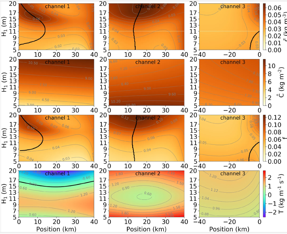
An estuarine turbidity maximum (ETM) results from various subtidal sediment transport mechanisms related to, e.g., river, tides, and density gradients, which have been extensively analysed in single-channel estuaries. However, ETMs have also been found in estuaries composed of multiple interconnected tidal channels, where the water and suspended fine sediments are exchanged at the junctions with possible occurrence of sediment overspill. The overall aim of this study is to understand the processes that determine the ETM dynamics in such channel networks. Specifically, focusing on the ETMs formation due to sediment transport by river flow and density-driven flow, the dependence of ETM locations in an idealised three-channel network on fluvial sediment input and the local deepening and narrowing of a seaward channel is investigated. It is found that the ETM dynamics in channels of a network is coupled, and hence, changes in one channel affect the ETM pattern in all channels. Sensitivity results show that, keeping river discharge fixed, a larger fluvial sediment input leads to the upstream shift of ETMs and an increase in the overall sediment concentration. Both deepening or narrowing of a seaward channel may influence the ETMs in the entire network. Furthermore, the effect of either deepening or narrowing of a seaward channel on the ETM locations in the network depends on the system geometry and the dominant hydrodynamic conditions. Therefore, the response of the ETM location to local geometric changes is explained by analysing the dominant sediment transport mechanisms. In addition to the convergence of sediment transport mechanisms in single-estuarine channels, ETM dynamics in networks is found to be strongly affected by net exchange of sediment between the branches of a network. We find that considering the sensitivity of net sediment transport to geometric changes is needed to understand the changing ETM dynamics observed in a real estuarine network.
Turbidity maxima in estuarine networks: Dependence on fluvial sediment input and local deepening/narrowing with an exploratory model
Jinyang Wang, Yoeri M. Dijkstra, Huib E. de Swart
Frontiers in Marine Science 2024 Spotlight
An estuarine turbidity maximum (ETM) results from various subtidal sediment transport mechanisms related to, e.g., river, tides, and density gradients, which have been extensively analysed in single-channel estuaries. However, ETMs have also been found in estuaries composed of multiple interconnected tidal channels, where the water and suspended fine sediments are exchanged at the junctions with possible occurrence of sediment overspill. The overall aim of this study is to understand the processes that determine the ETM dynamics in such channel networks. Specifically, focusing on the ETMs formation due to sediment transport by river flow and density-driven flow, the dependence of ETM locations in an idealised three-channel network on fluvial sediment input and the local deepening and narrowing of a seaward channel is investigated. It is found that the ETM dynamics in channels of a network is coupled, and hence, changes in one channel affect the ETM pattern in all channels. Sensitivity results show that, keeping river discharge fixed, a larger fluvial sediment input leads to the upstream shift of ETMs and an increase in the overall sediment concentration. Both deepening or narrowing of a seaward channel may influence the ETMs in the entire network. Furthermore, the effect of either deepening or narrowing of a seaward channel on the ETM locations in the network depends on the system geometry and the dominant hydrodynamic conditions. Therefore, the response of the ETM location to local geometric changes is explained by analysing the dominant sediment transport mechanisms. In addition to the convergence of sediment transport mechanisms in single-estuarine channels, ETM dynamics in networks is found to be strongly affected by net exchange of sediment between the branches of a network. We find that considering the sensitivity of net sediment transport to geometric changes is needed to understand the changing ETM dynamics observed in a real estuarine network.
2021
Turbidity maxima in estuarine networks: Dependence on fluvial sediment input and local deepening/narrowing with an exploratory model
Jinyang Wang, Yoeri M. Dijkstra, Huib E. de Swart
Journal of Geophysical Research: Oceans 2021 Spotlight
Net water transport (NWT) in estuaries is important for, for example, salt intrusion and sediment dynamics. While NWT is only determined by river runoff in single channels, in estuarine networks, it results from a complex interplay between tides and residual flows. This study aims to disentangle the various contributions of these physical drivers to NWT in estuarine networks and investigate the sensitivities of NWT to variable forcing conditions, interventions, and sea level rise (SLR). To this end, a processes-based perturbative network model is developed, which accounts for the vertical flow structure to resolve density-driven flow driven by a vertically uniform along-channel salinity gradient. Other identified drivers are river discharge and three tidal rectification processes: Stokes transport and its return flow, momentum advection, and velocity-depth asymmetry. The model is applied to the Yangtze Estuary. NWT due to tidal rectifications and density-driven flow can be comparable to river discharge. Specifically in the North Branch, the direction of NWT may differ from the direction of river discharge. Varying river discharge mainly affects NWT as tide-river interaction is weak and density-driven flow is shown to be insensitive to salt intrusion. Conversely, variations in tidal amplitude strongly affect NWT related to tidal rectification and density-driven flow. The deepening (narrowing) of one channel (Deep Waterway Project), affected the NWT mostly through the density-driven flow (advection). Furthermore, NWT distribution in the Yangtze is insensitive to SLR up to 2 m because the effects of SLR on transport due to different drivers compensate each other.
Dependence of tides and river water transport in an estuarine network on river discharge, tidal forcing, geometry and sea level rise
Jinyang Wang, Yoeri M. Dijkstra, Huib E. de Swart
Continental Shelf Research 2021 Spotlight
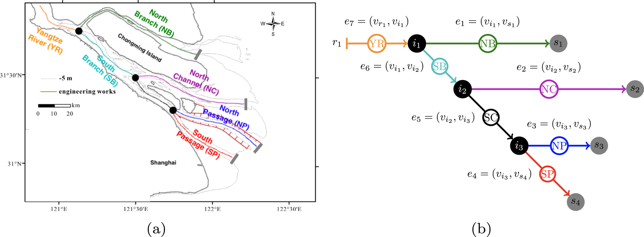
Estuaries are often characterised by a complex network of branching channels, in which the water motion is primarily driven by tides and fresh water discharge. For both scientific reasons and management purposes, it is important to gain more fundamental knowledge about the hydrodynamics in such networks, as well as their implications for turbidity and ecological functioning. A generic 2DV estuarine network model is developed to study tides and river water transport and to understand the dependence of their along-channel and vertical structure on forcings, geometry characteristics and sea level changes. The model is subsequently applied to the Yangtze Estuary to investigate tides and the distribution of river water over channels during dry and wet season, spring tide, as well as prior to and after the formation of Hengsha Passage and the construction of the Deep Waterway Project and sea level rise. Increasing river discharge enhances the friction for tides by increasing both internal and bottom stresses. Changes in tidal forcing are correlated with the friction for both tide and river. A shortcut channel reduces the water level difference in adjacent channels, as well as tidal amplitudes difference. Sea level rise results in larger friction parameters and faster propagation of tides. The distribution of river water transport is hardly affected by above mentioned changes. Model results and current vertical structure are consistent with observations.
Dependence of tides and river water transport in an estuarine network on river discharge, tidal forcing, geometry and sea level rise
Jinyang Wang, Yoeri M. Dijkstra, Huib E. de Swart
Continental Shelf Research 2021 Spotlight
Estuaries are often characterised by a complex network of branching channels, in which the water motion is primarily driven by tides and fresh water discharge. For both scientific reasons and management purposes, it is important to gain more fundamental knowledge about the hydrodynamics in such networks, as well as their implications for turbidity and ecological functioning. A generic 2DV estuarine network model is developed to study tides and river water transport and to understand the dependence of their along-channel and vertical structure on forcings, geometry characteristics and sea level changes. The model is subsequently applied to the Yangtze Estuary to investigate tides and the distribution of river water over channels during dry and wet season, spring tide, as well as prior to and after the formation of Hengsha Passage and the construction of the Deep Waterway Project and sea level rise. Increasing river discharge enhances the friction for tides by increasing both internal and bottom stresses. Changes in tidal forcing are correlated with the friction for both tide and river. A shortcut channel reduces the water level difference in adjacent channels, as well as tidal amplitudes difference. Sea level rise results in larger friction parameters and faster propagation of tides. The distribution of river water transport is hardly affected by above mentioned changes. Model results and current vertical structure are consistent with observations.
2020
Sensitivity of tides and net water transport in an estuarine network to river discharge, network geometry and sea level rise"
Jinyang Wang, Huib E. de Swart
EGU General Assembly 2020 Spotlight
Quite a number of estuaries are characterised by a complex network of branching channels, in which the water motion is primarily driven by tides and river discharge. Examples are the Berau estuary (Indonesia), the Pearl estuary (China) and the Yangtze estuary (China). Knowledge about tides are required for construction of dikes/harbours, while knowledge about net water transport is important for agriculture, fresh water supply to cities and for quantifying transport of sediment, nutrients and etc. In this contribution, we present a generic, weakly nonlinear 2DV estuarine network model to study tides and net water transport and to understand the dependence of their along-channel and vertical structure on geometric characteristics and sea level changes. The model will be applied to the Yangtze Estuary for different situations, such as the wet and dry season, with and without a shortcut channel and sea level rise for scenarios for the coming 50 to 100 years. It will be demonstrated that, for the current conditions, the model results are in good agreement with observations. Both tidal amplitude and current are weaker during the wet season than that during the dry season and the reason for these changes will be explained in terms of river-tide interactions. Effects of local changes in geometry are investigated by creation of a shortcut channel between two main channels. Results show that changes in tides are merely local, but they can be rather strong. Sea level rise (up to 2 meters) causes tides to increase, mainly as a consequence of less friction resulting from larger water depth. Net water transport turns out to be less sensitive to geometry and sea level rise compared to tides.